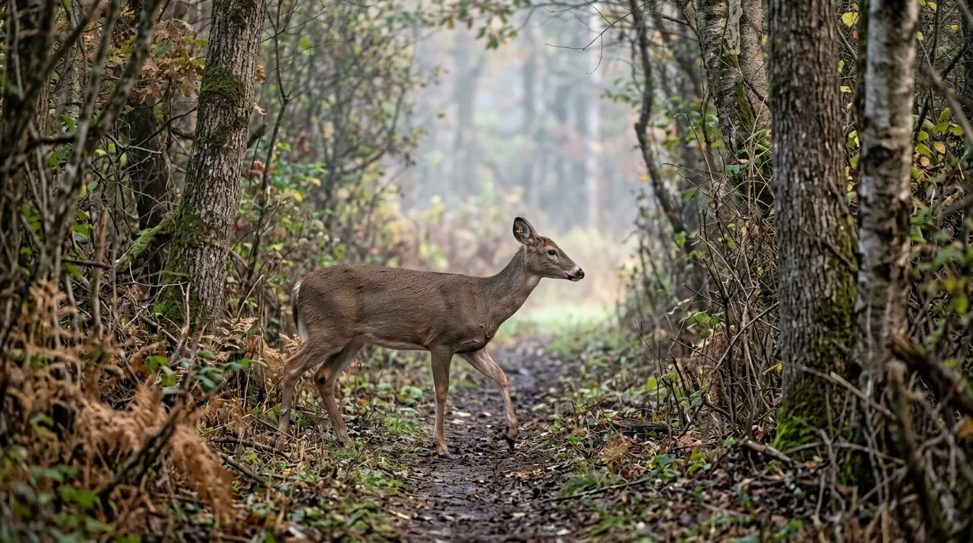
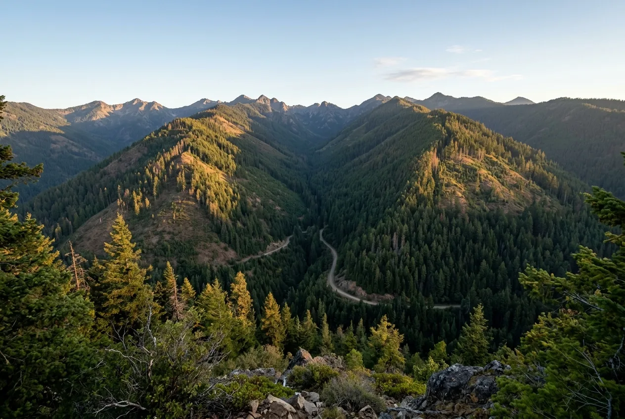
A deer is, before anything else, a machine for not spending energy it doesn't have to. Walk a property the way a deer walks it and you stop seeing a forest and start seeing a set of choices: cross the open field or skirt the wooded finger; climb straight over the ridge or slip through the low notch; wade the creek four times or swing around the one sharp bend. The deer almost always picks the cheaper, more covered option. Do that for a few thousand deer-years and the landscape develops seams — narrow places where the easy, hidden route is the only route — and that is where you want to be sitting.
Hunters call those seams funnels and pinch points, and they're not folklore. The same chokepoints show up when ecologists put GPS collars on red deer in the Alps and run the data through connectivity models: the movement concentrates into "pinch points... located in areas connecting the largest forested mountains with the largest and closest forested areas in the lowlands". A pinch point is just a place where the alternatives run out. The skill this article is about is learning to see those places — on a map, then on the ground — and to read them well enough to put a stand on the route instead of on top of the bed.
Why deer move in lines, not clouds
If you remember one thing, make it this: a deer's day is mostly a commute. It beds in cover where it feels safe, it travels to food and water, and it travels back. Mississippi State's Deer Lab, synthesizing years of GPS work, puts it plainly — deer move "to safely find food, water, and shelter," and because the best food isn't spread evenly, "meeting nutritional needs is the primary driver of deer movement most of the year". Everything else — the rut, weather, hunting pressure — bends that commute but doesn't erase it.
A deer's day is mostly a commute: bed to food, food to bed, by the cheapest covered route it can find.
The "cheapest covered route" has two ingredients, and it's worth keeping them separate in your head because they don't always point the same way.
The first is energy. Deer prefer routes that cost less to walk. When researchers tracked dispersing elk through the Rockies, the corridors those animals chose were "characterized by higher forage availability and slightly lower ruggedness" than random paths — they routed around the roughest ground, especially while actually on the move. That's the physical basis for everything a hunter means by a "funnel": a saddle is cheaper than the ridge top, a bench is cheaper than the sidehill, a gentle draw is cheaper than a bluff. (One honest caveat from that same elk study: at the broadest landscape scale there was "no clear overall avoidance of rugged terrain" — the effect is strongest up close, at the scale of an individual choosing its next few steps. Don't oversell terrain as a law of physics; treat it as a strong tendency.)
The second ingredient is security, and during daylight it often matters more than energy. The single clearest demonstration comes from a large, recent study of 243 GPS-collared red deer across the central Alps: "during the day, red deer avoided habitats where encounters with humans were likely," selecting "denser tree cover, greater distances from trails, steeper slopes, and higher elevations" — and then at night the pattern reversed, the deer dropping into lower, flatter, more open ground to feed. Read that twice, because it's the whole game. The daytime travel route hugs cover and broken terrain not because it's the shortest line but because it's the safe one. A whitetail study in South Carolina found the same split by sex: bucks selected hardwood drains — a classic terrain funnel — during the day, while does spent more of the daylight near food plots.
So the route a deer takes in legal shooting light is the intersection of two things: where it can walk cheaply, and where it can stay hidden. Find a place where the terrain forces both — narrow, low, and covered — and you've found a corridor.
The path of least resistance, in the agencies' own words
This isn't a hunter superstition that the science merely tolerates; it's the working vocabulary of state wildlife agencies. Indiana's DNR, in its scouting guidance, tells hunters to "read the landscape to find obstacles or terrain that can restrict a deer's movement and force it to come through a particular area. These are called funnels or pinch points. Examples include creek crossings, openings in briar thickets, and gaps in fences". The same page: "Deer frequently use the path of least resistance. Finding a well-worn trail with fresh tracks is a sign of an active travel route".
Missouri's Department of Conservation says it just as directly: "Ponds, rivers, creeks, and lake arms can help hunters by creating pinch points. Deer generally choose the path of least resistance and will cut closely around coves or across pond dikes". When two independent agencies and a stack of GPS studies all land on the same sentence, you can build a hunt on it.
The terrain features worth learning
You don't need to memorize a geology textbook. A handful of features account for most of the predictable funneling, and they fall into two families: topographic funnels (made by the shape of the ground) and cover funnels (made by vegetation). Here's the working set.
| Feature | What it is | Why deer use it | Where the stand goes |
|---|---|---|---|
| Saddle | A low dip in a ridge, or a low gap between two ridges | The cheapest place to cross high ground | In or just off the notch, on the downwind side |
| Ridge point / spur end | Where a ridge tapers to a point | Trails off both sides converge at the tip | At the convergence below the point |
| Bench | A flat shelf partway up a slope | A level, low-effort travel lane across a hillside | On the bench, downwind of the trail |
| Draw / drainage convergence | Where several small draws or finger ridges dump into one bottom | Routes funnel together into a hub | At the hub, minding swirling wind |
| Creek / river bend | A sharp outward bend in a waterway | Deer swing around the point to avoid extra crossings | On the inside of the swing, downwind |
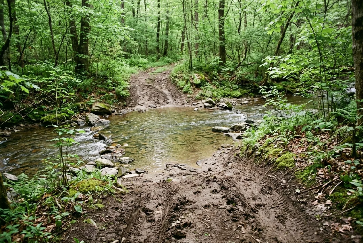
| Creek crossing | A shallow, firm spot to cross water | The water funnels all traffic to the easy crossing | Overlooking the crossing |
| Edge / inside corner | Where two habitats meet, especially where field points face each other | Deer travel and stage along cover edges | At the corner or where points pinch the gap |
| Cover funnel | A neck of brush, grass, or timber between open areas | Concealed deer follow the cover | In the narrowest part of the neck |
Let's walk through the ones that earn their keep.
Saddles
A saddle is the most reliable terrain funnel there is, because it's the textbook path of least resistance. The National Deer Association describes it as "a low spot on a ridge or a low spot between two ridges, where deer would be most likely to cross," and ties it straight to energy: deer "prefer routes requiring minimal energy expenditure". MeatEater's Wired to Hunt calls it "a small dip in the middle of" a ridge — "a naturally easier way to cross". Picture standing on a ridgeline and wanting to get to the other side without climbing the high points: you'd drift to the low spot and cross there. So does the deer.
One refinement from the NDA worth keeping: the saddle that produces is usually the one near good cover and not already hunted by everyone. Mature bucks "rarely expose themselves in open timber during daylight", so a wide-open saddle in mature woods may only run at night, while a saddle with a brushy lip can move a buck in shooting light.
Ridge points and benches
Where a ridge tapers down to a point, the trails running along each side tend to "come together at the end of a point," creating a funnel as more deer pass through that single spot. Points pull double duty — deer also like to bed on them, because a point lets an animal watch the low ground ahead and catch scent from behind — so a point can be both a bedding feature and a travel pinch depending on exactly where you are on it. That ambiguity is a theme worth flagging: the same feature can serve travel or bedding, and the difference of fifty yards is the difference between a great morning setup and bumping deer out of bed.
Benches — flat shelves running across a slope — are quieter funnels that a lot of hunters walk right past. A deer crossing a steep hillside will gladly use a level shelf rather than sidehill the whole way, so a bench becomes a travel lane. On a map they show up where the contour lines briefly spread apart on an otherwise steep face.
Draws, drainages, and their convergences
A single draw is a low, often-wooded line that gives deer cover, sometimes water, and easy grade — the NSSF's hunter-education guide describes draws and valleys as "the natural highways deer prefer, especially where multiple small draws funnel into a bigger bottomland". The money spot is the convergence. The NDA's name for it is a "crow's foot" — "an area where multiple finger ridges all dump into a single drainage," with deer traveling the sides of the fingers and intersecting at the bottom. It's a natural travel hub, and it's "particularly effective during the rut" when bucks are cruising.
A crow's foot — where several finger ridges all spill into one drainage — is a travel intersection the rut funnels every cruising buck through.
There's a catch, and it's about wind. Those same drainage convergences are where thermals get ugly. We'll come back to the wind in its own section, because the feature that concentrates deer also concentrates your scent.
Creek and river bends and crossings
Water shapes movement two ways. A sharp outward bend in a creek funnels deer around the point of the bend, because cutting across would mean crossing the water more than once; the deer swings wide on the dry side. The inside of those sharp bends, by contrast, is often bedding — with water wrapping three sides, a deer only has to watch the fourth, so it can rest covering one direction with its nose. So a single bend hands you both a likely bed and a likely travel route, a few dozen yards apart.
Then there are crossings: where a creek narrows or firms up, all the traffic concentrates at the one good spot. Missouri's advice is to "watch closely along creek edges for crossings. Often these areas are soft, causing worn trails that are easy to spot". There's good GPS evidence underneath this. In southwestern Wisconsin, dispersing young bucks "selected for areas near rivers and streams," using riparian lines as travel corridors — while big rivers acted as "semipermeable barriers" that funneled the crossings to a few spots; the Wisconsin River was nearly impassable, crossed by a single collared deer in the whole study. A barrier plus a rare crossing is the definition of a pinch point.
Independent European work says the same thing about where deer cross open ground. Tracking roe deer across the Alps and central Europe, researchers found road crossings were "more likely to occur during longer steps and in more forested areas" — the deer cross where there's cover, funneling through the wooded gap. Whether it's a creek or a county road, deer cross at the concealed pinch, not at random.
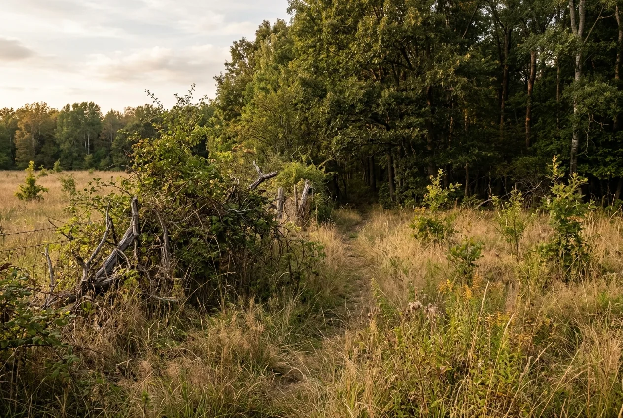
Edges and inside corners
An edge is simply where one habitat meets another — woods to field, timber to clearcut, thicket to mature stand — and deer travel and feed along edges relentlessly. Indiana DNR: "Transitions or edges where one habitat type meets another are great places to find deer sign. Edges of woods where they meet agricultural fields are a great example". This isn't soft observation, either; it falls out of a very large dataset. A study of more than 74,000 deer-vehicle collisions across Bavaria — collisions being, bluntly, a record of where deer cross — found that forest-edge density was a leading predictor of where those crossings clustered. Edge concentrates movement at landscape scale.
The sharpest version of an edge is the inside corner. Missouri's guidance is to notice "where forested habitats jut out into fields, especially where two points jut out across from each other"; a traveling deer "will tend to cross a field from point to point" rather than expose itself in the open middle, because it feels "more comfortable feeding in the open when there is cover nearby". Two timber points facing each other across a field neck the open ground down — and the deer threads the gap. That's a cover funnel you can spot on aerial imagery in seconds.
Linear features: the corridors that connect everything
Step back from individual features and you'll notice that a lot of them are linear — long, thin strips of cover that run across an otherwise open or hostile landscape. Creek bottoms, hedgerows, fencerows, field margins, strips of standing crop. These are corridors in the truest sense, and they're where the European and American evidence shakes hands.
Washington's Department of Fish & Wildlife says it cleanly about riparian strips: "The linear shape of riparian areas makes them a natural corridor for animals to move through the landscape," serving as "major corridors for large migratory species such as elk and as shorter movement corridors for smaller mammals". On the farmland side of the Atlantic, the British Deer Society describes roe deer leaning on exactly the same kind of feature: "hedgerows and field margins offer rich forage and safe corridors for movement," letting does "move discreetly between feeding and bedding sites". Different continent, different species, identical logic — a thin ribbon of cover is a road.
Even standing crops do it. Missouri notes that "standing corn provides extra cover and travel routes to keep deer concealed". Any long strip that lets a deer move without breaking into the open is a candidate corridor, and the narrower it pinches, the better your odds.
A word of honesty here, because it's the kind of thing that separates a useful article from a confident-but-wrong one. Linear features and valley bottoms aren't always the highway — it depends on what's disturbing the deer. When researchers ran a step-selection analysis on roe deer in a fragmented farm landscape in France, they expected the deer to "move preferentially along valley bottoms and through the more wooded areas." Instead the model showed the deer "tend to avoid buildings, roads, valley bottoms and possibly the more wooded areas," with distance-to-buildings and distance-to-roads the most influential variables of all. In that human-dominated patchwork, avoiding people overrode the pull of the terrain — the deer skipped the valley bottoms because the valley bottoms had houses in them. The lesson isn't that terrain reading fails; it's that security wins ties. Map the cheap route, then ask what's disturbing it, because a corridor with a road or a house in it may run only after dark.
Read the wind by mechanism, not by a compass
You cannot talk about travel routes on terrain without talking about wind, because deer route by their nose as much as by their legs, and so must you. The part most worth understanding is thermals — the vertical drift of air driven by temperature, separate from the weather-system wind.
The mechanism is simple and it's the same everywhere on Earth. As onX's breakdown puts it: "As the sun rises, it warms the ground... the air near the surface becomes warmer. This warmer air begins to rise because it is lighter than the cooler air above it." Then, "as the sun sets and begins cooling the air, those cold temps cause the air to drop and thermal winds move downward". Warm air rises; cooling air sinks. That's the whole rule, and notice it has no compass direction in it — which is exactly why it works in any hemisphere. Forget "the wind comes from the north"; think "in the morning my scent lifts uphill, in the evening it pools downhill." Even modest relief does it — "thermals can occur in as little as a 50-foot elevation change," the difference between a creek bottom and its banks.
Warm air rises by day, cools and sinks by evening — read your scent by that mechanism, in any hemisphere, not by a fixed direction on the compass.
This is where terrain and wind tangle together. Remember the crow's-foot drainage convergence — the great travel hub? It's also a thermal hub: a spot "where several draws or drainages meet, creating swirling winds that make scent control particularly challenging". The feature that funnels deer to you also stirs your scent into a vortex. The practical move is to play your elevation relative to the deer — generally staying above bedded deer in the morning as thermals rise, and below them in the evening as thermals fall — and to treat the upper third of a leeward slope, which onX calls "an absolute nightmare" of shifting wind, as a place to avoid setting up.
Terrain also lets deer use the wind, and that produces one of the most useful tactical details in this whole topic. On a ridge, deer typically "travel not on top of a ridge, but rather about 3/4 of the way down the side... to avoid being skylit". Walking partway down the leeward side keeps a deer off the horizon and lets the rising or falling air carry scent of anything ahead or behind. So when you find a ridge that funnels travel, don't expect the trail on the crest — look for it a third of the way down the sheltered face, and hang accordingly.
When they actually move: dawn, dusk, and the rut
A corridor only pays off if you're there when the deer is. The timing is one of the most consistent findings in deer biology, and it's pleasingly hemisphere-neutral because it's defined by light, not by a clock or a calendar.
Deer are crepuscular — built for the half-light. Tracking red deer in the Netherlands and elk in Canada, researchers found both populations had "crepuscular activity rhythms with the highest level of locomotor activity taking place in the first hours after civil twilight onset at dawn and civil twilight offset at dusk". Mississippi State's whitetail data agrees: about 60% of the behaviors deer show during twilight hours are feeding or walking, with bucks bedded most often in the middle of the day. European agency guidance for roe deer says the same — they "feed mostly at dawn and dusk" with "long periods... spent 'lying up' between feeding bouts". First light and last light are when the commute happens, so that's when your stand on the corridor earns out.
Two timing wrinkles change which corridors matter:
- The rut. During breeding, bucks abandon the cautious commute and start covering ground — Mississippi bucks moved "over 7,500 yards (4 miles) total per day" at peak rut, against roughly 4,000 yards earlier in the fall. A cruising buck is far more likely to use a daytime travel hub like a crow's foot or a saddle, which is exactly why those features get the "rut" reputation. Breeding-season excursions and dispersal are when corridors carry their heaviest, least-predictable traffic.
- Pressure. Push deer too hard and they go nocturnal. Roe deer that are "frequently disturbed... may become increasingly nocturnal, making more use of open spaces during the hours of darkness"; whitetails do the equivalent, shifting their feeding to the cover of night when hunters are active. A corridor that was a daylight highway in October can go quiet by November if you've over-scouted it. Get in clean, hunt it when conditions are right, and don't burn it.
And a myth worth killing while we're here, because it eats a lot of hunters' planning: moon phase. The Mississippi State GPS data is blunt — there is "absolutely no pattern of variation that can be associated with moon phase" in daily movement. Plan around light and pressure, not the lunar calendar.
Finding corridors on a map, then confirming on the ground
Here's where it comes together into a workflow. The features above are findable from a screen before you ever set foot on a property, and the smart sequence is map first, boots second, stand last.
Step 1 — Read the map. On a topographic map, learn to see the features by their contour signatures. The NSSF guide is a good crib sheet: tightly packed lines mean steep ground, widely spaced lines mean gentle slopes and flats; a saddle shows where "contour lines squeeze into an hourglass or figure-eight shape"; ridges read as "U" or "V" contours whose closed ends point downhill, while valleys and draws are "U" or "V" shapes pointing uphill. Pinch points are "narrow saddles between ridges, tight draws carved by streams or slim strips of cover" that "concentrate movement much like a bottleneck funnels water". Then switch to aerial imagery for the cover funnels the contours can't show — the inside corners, the hedgerows, the necks of brush, the standing-crop strips. Mark every saddle, point, draw convergence, bend, crossing, and inside corner. MeatEater's framework is to study aerial and topo maps and mark every instance of these features before you go.
This is the natural moment to map digitally and keep your marks. Reading terrain to predict movement is exactly the macro pattern agency scientists confirm at scale — the USGS, mapping mule deer and elk migrations across the western U.S., describes corridors where terrain "condens[es] routes," funneling animals through narrow passages where highways, rivers, and topography converge. The same logic that condenses a herd's migration through a valley condenses a single buck's daily route through a saddle. It's also worth knowing which segments are pure travel: mule-deer migration routes break into "a series of stopover sites where deer spent most of their time, connected by movement corridors through which deer moved quickly". A pinch point is usually a move-fast segment — somewhere deer pass through, not linger — which is exactly why it's an ambush, not a feeding spot.
Step 2 — Verify the sign. A feature on a map is a hypothesis, not a stand site. Get in and look for worn trails with fresh tracks — the agencies' tell for an active route — plus rubs and scrapes. One discipline rule from Indiana DNR that's worth tattooing on the inside of your eyelids: "Don't set up a tree stand over the first new tracks you find... The best locations to hunt have large quantities of multiple types of sign". A single trail is noise; a saddle with a worn trail, fresh tracks, a rub line, and a crossing all stacked together is signal. Missouri adds a nice diagnostic for telling travel from bedding: "linear rub lines that indicate buck travel routes" versus "circular rub lines around thickets... [a] core bedding area". Linear means he's passing through; circular means you're at the bedroom door — back out.
Step 3 — Confirm with cameras, then commit. A camera on a funnel does what your eyes can't: it watches the spot for two weeks while you stay away, telling you whether deer use it, when, and whether any of them are what you're after. MeatEater's three-step framework is explicit about it — study maps, speed-scout to verify sign "and potentially place trail cameras," then hunt the best of them. Cameras also settle the daylight question that decides everything: a saddle that only logs deer at 2 a.m. is a different proposition than one with a buck walking through at last light. Let the corridor prove itself on camera before you hang a set and start adding your scent to it.
Hunt the route, not the bed
Everything in this article points at one decision, and it's worth stating outright because it's the most common way good scouting gets wasted. You set up on the travel corridor between bedding and food — not on the bedding area itself.
The reasoning is all in the deer biology. Bedding cover is where the deer feels safe; intrude on it and you teach the deer that its sanctuary isn't safe, and it relocates or goes nocturnal. The corridor is where the deer is committed to moving, in the open enough to give you a shot, predictable enough to be there at first or last light. Mississippi State's recommendation is exactly this: managers should "build corridors of cover that link bedding areas to food sources," and then "this is the type of area where you want to put a stand to catch a buck or any deer moving between bedding cover and nutrient patches". The state agencies converge on the same point — converging trails make "excellent stand sites because deer trails often converge at these locations".
Set up where the deer is committed to moving — the corridor between bed and food — never on the bed itself, which you can only ruin by hunting.
It helps to know which deer you're playing for, because they don't all use the landscape the same way. Mississippi State found that roughly a third of adult bucks were "mobile," ranging over an average of more than 12,000 acres across two seasonal home ranges, while two-thirds were "sedentary," living their whole year inside an average of under 800 acres. A median annual home range was about 860 acres — but a quarter of bucks used less than 500, and another quarter used more than 2,000. A mobile buck might vanish from your cameras for weeks and reappear having commuted miles down a single corridor between his ranges. That's the deer the funnel earns you — the one you'd otherwise never see, caught at the one narrow place his route has to pass through.
Then put the wind on top of the route. The right stand is on the corridor, on the downwind side, with your thermals working for you — above the deer in the morning, below in the evening, off the swirling drainage hubs and the leeward upper third. Map the funnel, confirm the sign, read the wind, and sit where the terrain has already done your hardest work for you.
Frequently asked questions
What's the difference between a funnel and a pinch point?
In practice they're used interchangeably for any spot where terrain or cover squeezes deer movement into a narrow path. If you want a distinction: "funnel" emphasizes the shape that gathers deer in, "pinch point" emphasizes the chokepoint where alternatives run out. Connectivity scientists use "pinch point" specifically for a narrow link where movement concentrates because there's no other way through.
What terrain features funnel deer the most reliably?
Saddles (low crossings in a ridge), draw and finger-ridge convergences ("crow's feet"), sharp creek and river bends, creek crossings, and inside corners where two timber points pinch a field gap. Cover funnels — necks of brush, hedgerows, standing-crop strips, and edges between habitats — funnel deer just as hard and are easiest to spot on aerial imagery.
Should I hunt the bedding area or the trail?
The trail — specifically the travel corridor between bedding and food. Hunting the bed itself pressures deer into going nocturnal or relocating; the corridor catches them moving, in shooting light, without poisoning their sanctuary.
When are deer most likely to be using these corridors?
At first light and last light. Deer are crepuscular, with their heaviest movement in the hours around dawn and dusk twilight. During the rut, bucks travel far more and far less predictably, which is when daytime hubs like crow's feet and saddles produce best.
Do these terrain rules work outside North America?
Yes — the underlying logic (least energy, most cover) is universal, and it's been confirmed independently in European red and roe deer. Alpine red deer pick covered, broken terrain by day; roe deer use hedgerows and field margins as movement corridors between feeding and bedding. One caveat: in heavily settled landscapes, avoiding people can override the pull of the terrain, so a valley bottom with houses in it may go unused.
Does moon phase tell me when deer will move through a funnel?
No. GPS data shows "absolutely no pattern" between moon phase and daily deer movement. Plan your corridor sits around light (dawn/dusk), the rut, weather, and how much pressure the spot has had — not the lunar calendar.